Friday, May 1, 2015

Climate Change Impacts in New Zealand


The observed impacts said to be caused by climate change falls into three categories: physical systems, biological systems, human and managed systems. The major observed impacts with a confidence rating of very high on biological systems are wildfire, marine and terrestrial ecosystems. For physical systems impacts are on glaciers, snow, ice, and/or permafrost (IPCC, 2013). Human and managed systems include food production, livelihoods, health and/or economics but only with a lower confidence rating of medium. For the IPCC New Zealand is thrown under a region called Australasia for climate change analysis. In the report, one key risk described for new Zealand is an increase in rates and magnitudes of damages to cities and infrastructures due to flooding. The other risk affecting New Zealand damage to coastal infrastructure and ecosystems that is lower in elevation (IPCC, 2013).


On a seasonal scale New Zealand’s precipitation is affected by the Southern Annual mode (SAM) which is region of westerly winds near Antarctica that when said to be positive when it move towards Antarctica and negative when it moves towards equator. Rain fall is typically increased in western new Zealand when SAM is negative and/or during el NiƱo events. When SAM is positive and/or during la Nina events rainfall is increased in the north and east.  In the last century New Zealand temperature has just shy of 1C. A subtropical high-pressure belt is expected to move pole ward causing dry conditions in part of the country. With this combo of drying in some part and increased precipitation in others, it is suspected that flooding and droughts will increase twofold (IPCC, 2013).

One thing is for sure, the regional climate is changing. Warming will not stop, it is expected to keep increasing even into the 21st century when currently were all dead (hopefully). There are issues in predicting changes in rainfall for Australia and new Zealand which presents a large challenge in preparation. Recent extreme climatic events such as bleaching of coral reefs in northeastern and western Australia, flooding, and heat waves mercing people show that ecosystems are vulnerable like a man admitting that enjoys the show “Friends”. If something isn’t done to adapt to these changes GHG’s and ocean acidity will have wreak havoc on water resources, coastal ecosystems, infrastructure, agriculture and human health. Though things look shivvy, some locations may reap benefits of fewer deaths in the winter and heating bills. When it comes to adaptation everything’s fine a dandy but action is taken more in a conceptual sense then one of implementation. The indigenous people of Australia and new Zealand feel strongly connected to the land and highly rely on industries that sensitive to climate change leaving them more vulnerable to climate change (IPCC, 2013). Studies have much limitation leaving out important socioeconomic dimensions such as getting old, current or changing societal values, richness of richy rich people, and labor stuffs. Bottoms line is that we don’t know enough, were not doing enough, and we may be screwed.

Australia’s gets 2.6 to 4% of its GDP from tourism with the great barrier reef to have an estimated worth of about $51.4 billion over the next century. Tourism for Australia will be quite challenged by climate change as the reason to visit Australia is mostly is environmental (IPCC, 2013). No one goes to Australia to visit McDonalds or watch movie. Extreme events such as floods and tropical cyclone Yasi in 2011 caused a loss of AU $590 million! Just due to cancellations and damage to the Great Barrier Reef. See, told ya environmental ish. While shit is hitting the fan in Australia, people are starting to consider visiting New Zealand instead (IPCC, 2013). While Australia and new Zealand are losing snow cover, new Zealand is losing at a slower rate than Australia. In new Zealand snow making days will be reduced but amount of snow making needing to meet minimum ski conditions are said to be feasible into the 21st century. Why I chose tourism as an interesting issue is that I kind of hate tourism. Even though I’ve played tourist before I associate tourism with people who don’t give two shits about the environmental. Rich dicks that just come to trash everything I love and hold dear. Living in Hawaii I’ve seen how the ocean is a brothel and the islands are prostituted with Uncle Sam as the mamasan. Tourism is so important to place like Hawaii yet they are slowly destroying that which attracts people with development. Argh…


Drought in March 2013


1) evaluate efficiency of water washing and acid base extractions on deashing biochars; 2) determine the effect of deashed biochars on soil properties and plant growth, and 3) compare biochars with varying ash content on soil properties and plant growth. For objective 1 we hypothesize that 1) increasing treatment time of biochars in the hot water bath will increase ash removal, and 2) that acid base extraction will results in higher ash removal than water washing.  Addressing objective 2 we hypothesize that deashed biochars produces no benefits to plant growth. For objective 3, our hypothesis is that biochars with ash contentment will increase plant growth more than those with low ash.

Monday, April 13, 2015

Severe Weather in New Zealand


Tornadoes, Hurricanes, and the Isssshhh


Maaaaan, damnses weather, you scary!

Yous guyses know what a zornado es? And no... nots zat sharknados craps. Jeebus.. I mayses of watched it but that shiz could never happens! Everyone knows sharks are afraid of heights so they would never get caught up in a tornado let alone bite the shiz outta peoples while spinning around uber fast. 


 ..... however...................

...........


 ....................  Baboonami is real! 


Anywho,  A tornado is a rapidly rotating narrow region of low pressure.

Tornadoes first start as body of air just rolling around all stupid on the ground due vertical wind shear which is a gradient/ difference in winds speed and direction.

With a vertical shear the difference is between air aloft and surface winds.

 This rotating mass then is lifted off the ground by an updraft of a thunderstorm and once it is nearly vertical it is considered a mesocyclone.

This vertical cylinder of air narrows into a funnel cloud and once it touches the surface it is considered a tornado.

Funny, spellcheck thinks i meant to spell lonesomeness instead of mesocyclone...


This is pretty cool though.

So, in the US tornadoes move from southwest to south east. As with most weather movements and stuffs this movement is due to our prevailing westerly winds and also a jet stream.


Tornadoes also happen in New Zealand, hey what do ya know... And they are associated with a band of thunder storms (squall lines) that are balls deep in a strong unstable pre-frontal northwesterly flow. There's about 7 moderate to strong tornadoes in New Zealand a year.


Now for the US, according to the National Oceanic and Atmospheric Administration (NOAA)There an average of 1000+ tornadoes a year!


Up thurr is a map detailing the hotpots of tornado occurrences.

Areas shaded in orange are the most prone to have tornadoes and there that little big orangy thing to the southeast is New Zealand. We be feeling hot hot hot!


Now look at this ish. This here picture shows that tornadoes have increased over the years!

Oh no its climate change again! Oh wait, maybe not. Actually this increase may mostly be due to an increased ability to observe tornadoes with uber hitech scifi technology we have these days.


Hurricanes

The three main requirements for hurricane formation is a warm ocean temperature of greater than 80 degrees F (27C) because ya need evap.

A deepwarm ocean layer of ~200m in depth cuz when wind pulls up water you still gots that warm ish.

And that ole crazy Coriolis is needed to create that spin but only between greater than 5 North and 5 South cuz Coriolis is a weak mofo at the equator it's his kryptotonanight.


New Zealand does satisfy the requirement for Coriolis effect but does not satisfy the other two as the country lies further south so the ocean temps are not as warm and deep like countries between the equator and 20N, S.

Hurricanes typically form in three main regions where they also referred to as different names. Saaay whhaaaa?


 In the Atlantic and East Pacific they are called hurricanes; in the Indian Ocean near Australia, cyclones; off the coast of China and Indonesia, typhoons.


Hurricane, Cyclone, Typhoon, Whatever map
http://spaceplace.nasa.gov/hurricanes/en/cyclone_map_large.en.gif


As you can see in the diaphragm, hurricanes in 'Murica typically move north east due to the Toyota Corrolla effect pulling it north and the westerlies blowing it east. 


The average number of hurricanes that hit New Zealand (stop the violence :/ ) is 0 as Hurricanes do not happen in New Zealand.


They can occasionally get hit by the remnants of a hurricane during the months April-December where the ocean temperatures are higher around the islands. Mostly though, hurricanes just peter out before they come close to land.


Compare this to number to the US, which has an average around 1.75 hurricanes per year according to the Hurricane Research Division of NOAA.


Also, checkout this insane footage of a HURRICANE doing damage in New Zealand!!!


Saturday, April 4, 2015

Daily Weather in New Zealand

In my blog of the most epic proscratination skills  i will bust out a 3‐day forecast that will cover the days 4/4/15 to 4/6/15.

The forecasted high...


...for my first day is a quite enjoyable 68 F, which is freezing as balls to me but most mainlanders would love that ish. The forecasted low is 63 F with about 10% chance of precipitation during the day and night.

The forecasted high for my second day is 64 F with a forecasted low of 54...


... This time there is a 10% chance of precipitation but only in the day. Hope they mean rain and not death asteroids.


The forecasted high for my third day is a 69 F.. he.. he.. aha... The forecasted low is a 63 with about 30% chance of precipitation during the day and night. The average pressure over the three day period was about 30.11 with the pressure incresing over the three day period.


The average wind speed over the three day period was 21.67 km/ hr with the wind speed increasing over the three day period.

Now for some 8 bit looking clouds in a satellite image of Wellington.


 Yargh, der be some clouds i foresee.. ish. they're about 40km away so i guess that could be considered farish. There are mostly a mix of low warm and cold clouds. There is a light rain to the north. I knew there would be some cause New Zealands a rainy ass place.

New Zealands full of veggies and mountains and hobbit type shiz. There's two lakes to the west and a bunch of parks and reserves which makes me quite jelly.


Surface Analysis


Got high pressure to the southeast and a cold front running across New Zealand headed towards another high. We got dem isobars of 1008 to 1028.


Here's a closer look at that cold front hitting the whole country... I means its kinda small but yeah its kinda a big dealish. This map we isobars of 1005 to 1020.


Tuesday, March 24, 2015

Global and Local Winds in New Zealand

Yo back again with that New Zealand. I spit sick rhymes and thick flows like the the wind blows.

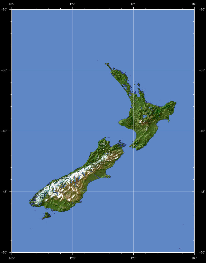
So this country of mine lies between the latitudes 34 S and 48 S; longitudes 166.5 E and 178.5 E.

So you know what that means dogs?! We be in the Southern Hemisphere!


Judging on our coordinates we are right in the same spot where Will Ferrell was born!

Oh wait... Never mind were just in the "Atmospheric Cell" called the Ferrel Cell. Laaaame.

The wind belt we habituate is of the Prevailing Westerlies. Kind of confusing since we rep the south... There will be issues..

Any who, those dang west side westerlies be frontin. Up in the northern hemisphere they blow from the southwest to the northeast but thangs are run differently down here in the south (cue Deliverance banjo song). Instead the westerlies blow from the northwest to the southeast.

Is New Zealand near a main pressure belt? Relatively? Depends on what one may think is close. I think close is where i can make food, do homework, and take a dump without moving but ya know.. but yeah i would say  it's close to a Subtropical High where the Horse Latitude lies. North Island sits at 35 S while the Subtropical High is at 20-30 S.

New Zealand is down with the oldschool with it being hit by the "Roaring Forties" which is  just these westerlies cats going pretty hard.


Gangster

Global wind and weather map

New Zealand gots the hook on mountains.  I mean look at this ish...


South Island has a long strip running right through the middle called the Southern Alps.

Here are some fools (breezes and winds) that associate themselves with mountains:

Breezes: Mountain and Valley
Winds: Katabatic, Chinook, and Foehn winds


With these here mountains we get a multitude of breezes/winds such as mountain and valley breezes, katabatic winds (Greymouth), and foehn winds cuz the alps (Moray Firth).

New Zealand is coo beans cuz its got choke coastlines.

Two breezes associated with coastlines are:
1.land breezes
2.sea breezes


New Zealand gets both of these winds as it is an island!

Honestly, New Zealand seems like it is windy as fuuuuuu. Probably great for kite flying no?

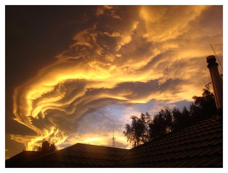
Interesting side note, on the Southern Island there receives Foehn Winds as mentioned before but they instead call it the "The Nor'wester". As its name hints, these dope ass winds comes from the north west and carries warm moist water from the evaporation of the Tasman sea that is pushed up the alps condensing it and blocked by the mountains leaving the windward side pretty wet and the leeward side dryyyy.

The clouds formed takes a pretty sick arch shape so they call it the Nor'west arch. It looks a lil like this...


Friday, March 6, 2015

Typical Weather and Tourism in New Zealand


*Yaaaay Tourism! Ruining everything that people of nature hold precious*

Solstices
Winter Solstice

New Zealand is beautiful as fuuuuuuuh. Since it lies in the southern hemisphere all the seasons are backwards. This all thanks to the mighty power of the sun. Seasons exist due to the change of the sun rays angle and the Earths tilt. When the southern hemisphere is tilted furthest away from the sun its experiences its shortest day which is considered the Winter Solstice! 

In New Zealand the Winter Solstice occurs on June 21st. During  the month of June New Zealand 's average maximum temperature is 12.2 degrees C (54.0 degrees F). The average minimum temperature is 3.9 degrees C (39.0 degrees). Not too cold but still snuggie worthy.

New Zealand is quite the rainy place so if there is any expected precipitation it will most likely be rain.

Summer Solstice

December is the start of summer in New Zealand meaning that New Zealanders have a cozy hot Christmas! The Summer Solstice occurs on the 22nd of December, just a few days before that great pagan holiday we cherish so much.

During the month of December New Zealand experiences a average maximum temperature of 15.7 degrees C (60.26 degrees F). The average minimum temperature is 11.0 degrees C (51.8 degrees F). Again New Zealand is rainy as shiiiiiii; if precipitation occurs its rain!


Equinoxes
Spring Equinox

Ah, the Spring Equinox... Pretty cool sounding word huh? Equinoxes happen twice a year (Spring and Autumnal)  where the earth is not tilted towards or away from the sun and so is subjected to an almost same amount of day and night!

The Spring equinox for New Zealand occurs on September 23rd and if it were to get dat crazy ass thing called precipitation than it would be rain yo!

The average maximum temperature during September is 10.2 degrees C (50.4 degrees F). The average minimum temperature is 5.7 degrees C (42.3 degrees F).


So... i bet you're wondering when does the Autumnal Equinox happen huh? Well if you guessed Rowburger you would be wrong! That's not even a month! You hungry? Now if you twas smart you would say it was March 20th! 

In March, average maximum temperatures hit 15.5 degrees C (60.0 degrees F). Average minimum temperatures smack 10.6 degrees C (51.1 degrees F). We really should switch to the Celsius scale... but noooo the U.S. is way to coo to do that. Stubborn jackasses. 

Again dat water rain stuff would happen if any precipitation would happen. This is mostly in the cities though as the mountains and mountainous towns get snow seemingly whenever.

Exploitation

If terrorists... I mean voyeurists... shiiiii I mean tourist were looking to come visit and ruin the beauty that is New Zealand, i would recommend that they come in summer after the Summer Solstice. That way they can enjoy the warm temperatures and long days in which to explore the island swimming and/or surfing. 

In summer there isn't really any weather hazards though New Zealand can receive some tropical cyclones or tornado but these are uber weak and usually can't do jack. 

Buuuut, the real reason that i recommend Summer is that due to a low ozone, clear skies, and a closer distance to the sun than Europe, tourists can be brought under siege by terrible sun burns! Muahahaha. 

During the summer UV rays can be unrelenting, even deadly! New Zealand has the highest rate of skin cancer! So go soak it up!

Also, when you go swimming the ripe tides can be beastly and drown your sorry ass. I am not evil, I'm just giving you a heads up. Serves you to trust a college student blogging about a country he's never been to.

But check this out....


Pretty sweet yeah?

"New Zealand.... Bilbro Baggin's Paradise"